


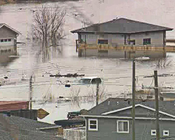
The province continues to respond to flooding in Fort McMurray and Mackenzie County. States of local emergency remain in effect in both communities.
Current situation
- Flooding, due to ice jams on the Athabasca and Clearwater Rivers in Fort McMurray and the Peace River in Mackenzie County, have led to evacuation orders for some residents of Fort McMurray, Fort Vermilion and Tallcree First Nation at Beaver Ranch.
- Fort McKay First Nation has activated their emergency management committee, although there is no flooding in the community at this time.
Evacuation orders
- The Regional Municipality of Wood Buffalo issued a
mandatory evacuation order for the entire community of Draper, Longboat
Landing, Waterways, Ptarmigan Trailer Park and the Taiga Nova
Eco-Industrial Park, and the entire lower townsite of Fort McMurray, except
for the Northern Lights Regional Health Centre and Grayling Terrace.
Access to the lower townsite is closed.
- Significant resources are being dedicated to berming and sandbagging the area surrounding the Northern Lights Regional Health Centre to mitigate flood risk. There is no threat to this area at this time.
- Mackenzie County has issued a mandatory evacuation order for residents within the Hamlet of Fort Vermilion who reside east of 50th Street, north of the golf course, River Road, and Boreal Housing and all of North Vermilion (Buttertown).
- Tallcree First Nation at Beaver Ranch is impacted by flooding and is being evacuated at this time.
- Flooding is also expected in Little Red River Cree Nation. An evacuation alert was issued April 27.
- As of April 27 at 10 p.m.:
- More than 13,000 people from Fort McMurray were evacuated to hotels, work camp facilities and private accommodations.
- About 446 people were evacuated from Fort Vermilion to hotels in High Level and private accommodations.
- Three people from the Tall Cree First Nation have been evacuated to a local hotel.
Information for evacuees
- In Fort McMurray, registration centres have been established at the Oil Sands Discovery Centre and the Casman Centre. Drive-through registration is offered to support physical distancing guidelines, however the municipality is asking evacuees to go only if they require accommodation or immediate support.
- Members of the public who are not already registered can report to the Casman Centre, at 110 Eymundson Rd., to register as evacuees.
- In Mackenzie County, residents should register by calling 780-927-3718.
- Tallcree First Nation members are in direct contact with the Tribal Government.
Road closures
- Highway 63 remains open at this time.
- Highway 88, northwest of Fort Vermilion, is closed to traffic due to flooding of the Peace River. Residents south of the Peace River can use Highway 88 to travel south. Residents north of the Peace River can use Highway 58 to travel west and then Highway 35 to travel south.
- Please visit https://511.alberta.ca for the latest information.
Drinking water and wastewater facilities
- Fort McMurray’s wastewater treatment plant has been evacuated, as the access road is flooded. It remains operational and is being monitored and operated remotely.
- Due to reports of discoloration in tap water, Fort McMurray and Alberta Health Services have issued a boil water advisory for all of Fort McMurray and rural hamlets of Anzac, Draper, Gregoire Lake Estates, Fort McMurray First Nation 46, and Saprae Creek Estates.
- The Peace River flood has caused a disruption in the water supply for the Hamlet of Fort Vermilion.
- The raw and treated water truck fill station in the Hamlet of La Crete and the Buffalo Head Prairie truck fill station are closed until further notice. Water is currently being hauled from the La Crete distribution line in order to meet water demands within the Hamlet of Fort Vermilion.
- Water usage is restricted to essential use only. The Fort Vermilion water treatment plant truck fill station is inaccessible, as it is located within the mandatory evacuation area.
- The Fort Vermilion rural truck fill is now closed until further notice, as the water treatment plant has been compromised by rising floodwaters.
- A boil water advisory has not been issued for Fort Vermillion at this time but will be issued if conservation of drinking water and essential use is not practiced.
River conditions – Athabasca and Clearwater Rivers
- The ice jam on the Athabasca River is approximately
24 kilometres long. The ice jam stretches from kilometre 281, just upstream of Willow Island, to kilometre 305, which is by Mountain Rapids. - The ice jam has caused a rise in water levels of between 4.5 and six metres on the Athabasca River. Athabasca water levels have held steady since Sunday evening.
- Clearwater River water levels have increased up to three-quarters of a metre since Sunday evening.
- The ice jam had darkened yesterday significantly, indicating that melting is taking place.
River conditions – Peace River
- The breaking ice front has reached Fort Vermilion and is continuing to move through town. The ice front is in place between Beaver Ranch and the downstream end of Fort Vermilion, causing flooding in both locations.
- The ice is still moving in Fort Vermilion. When last observed in the early morning of April 27, the total length of the ice jam and advancing ice was approximately 38 kilometres.
Albertans who live in affected areas should look for updates from their local government regarding evacuations and closures and download the Alberta Emergency Alert app. For the latest information on river conditions, visit rivers.alberta.ca or download the Alberta Rivers app.
How Albertans can help
In response to Canada's Online News Act and Meta (Facebook and Instagram) removing access to Canada's local news from their platforms, Anchor Media Inc encourages you to get your news directly from your trusted source by bookmarking this site and downloading the Rogue Radio App. Send your news tips, story ideas, pictures, and videos to info@anchormedia.ca.